
Wintry mix expected Friday across Central North Carolina: Weather timeline
Wintry mix expected Friday across Central North Carolina: Weather timeline
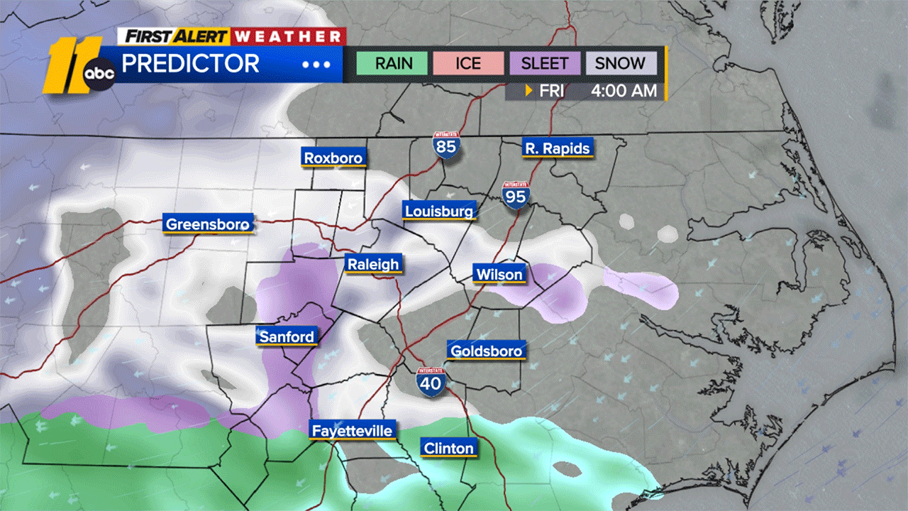
A wintry mix is set to impact the Triangle and areas to the north on Friday, with snow and ice possible early in the day before transitioning to all rain by the afternoon. The system could end as a mix again by evening.
Snow accumulation is expected to be around an inch or less, with minor ice potential north of the Triangle during the morning hours.
The wintry mix will likely create slow and messy commutes Friday morning, with rain continuing through the afternoon. Be prepared for tricky travel conditions.
Here’s a timeline for Friday’s weather:
4 a.m.: Snow showers and a wintry mix begin.
10 a.m.: Transition to a mix of rain, snow, and wet conditions.
12 p.m.: Rain takes over, melting any snow or slush.
Evening: Lingering showers possible.
Looking ahead, the 7-day forecast shows chilly temperatures sticking around:
Wednesday: Bright and chilly, with highs in the upper 40s and lows in the upper 20s.
Thursday: Mostly cloudy, highs in the low 50s, lows in the low 30s.
Friday: First Alert Day. Wintry mix transitioning to cold rain, with highs in the upper 30s and lows in the low 30s.
Saturday: Cloudy with isolated showers, highs in the mid to upper 40s, and lows in the upper 20s.
Sunday: Partly cloudy, highs in the upper 40s, and lows in the low 30s.
Monday: Partly cloudy, highs in the low 40s, and lows in the low 20s.
Tuesday: Chilly, with highs in the mid-40s and lows in the low 30s.
Copyright © 2025 WTVD-TV. All Rights Reserved.
2025-12-03 15:33:00